7.7 MAGNITUDE EARTHQUAKE STRIKES PANAMA, TRIGGERING TSUNAMI ALERTS
USGS confirms a 7.7 earthquake in Panama on October 9. Tsunami threat has passed; damage, injuries and service disruptions remain under assessment.
A magnitude 7.7 earthquake struck southern Panama on October 9, 2026, damaging buildings and disrupting services. The reviewed USGS record places the epicenter 12 km west-southwest of Pitaloza Arriba. An initial Pacific tsunami threat prompted regional alerts, but NOAA’s Pacific Tsunami Warning Center subsequently declared that threat over. The alert history must not be read as an active warning.
Verification cutoff: October 9, 2026, 22:30 UTC (17:30 in Panama). Measurements and damage assessments may be revised. This report distinguishes reviewed seismic data, attributed preliminary assessments and information not yet established.
Image disclosure: the hero is an AI-generated editorial illustration. It is not an authentic photograph of earthquake damage or rescue work. The destruction depicted in Panama City has not been verified by this image. The USGS map below is a separate, official scientific product.
The confirmed seismic measurements
The USGS event data give a reviewed moment magnitude of 7.7, an origin time of 17:56:06 UTC, or 12:56:06 in Panama, and coordinates of 7.5868° north, 80.7690° west. Depth is 12.647 km, conventionally rounded to 12.6 km. The event identifier is us6000u18k. These are the values used in this article, not the older 33 km depth circulating in initial tsunami bulletins.
Early estimates changed. AP reported the progression from 8.0 to 7.6 and then 7.7. Local reporting also relayed a 7.2 estimate from Panama’s geosciences institute. Those agency estimates should remain attributed, not averaged. A reviewed catalog entry can still change as more data are analyzed. The official USGS ShakeMap estimates shaking intensity across the region; it is not a building-by-building damage survey.
October 9, 2026. Verification cutoff: 22:30 UTC. Event us6000u18k. Magnitude and intensity measure different things; reviewed values can change.
- Moment magnitude
- 7.7
- Depth
- 12.6 km
- Origin time, UTC
- 17:56:06
- Epicenter coordinates
- 7.5868° N, 80.7690° W
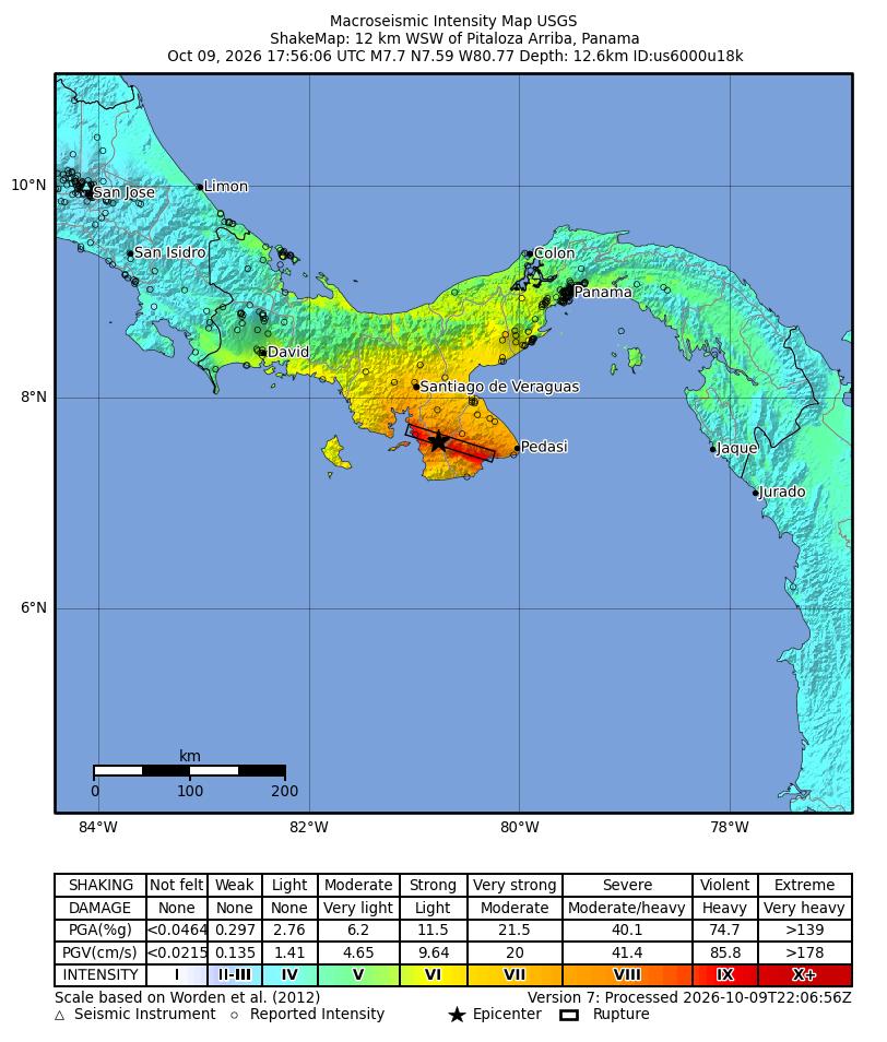
USGS ShakeMap, version 7, processed October 9 at 22:06:56 UTC. Colors estimate shaking intensity, not observed building losses. The star marks the epicenter. Native map labels and intensity legend are in English.
Source: USGS Earthquake Hazards Program. Open the reviewed USGS event. Open the official full-size map.
PRESDA Data Graphics
Damage and the limits of the casualty report
Panamá América’s 15:00 local report quoted SINAPROC deputy director Malitzie Rivera as saying no deaths had been reported at that stage and injured people in the central provinces had been taken to hospitals. It supplied no national injury total. No independently verified final death or injury count was established at this article’s cutoff. A preliminary absence of reported deaths is not proof that every community has been assessed.
Reuters verified video showing damage to a church and nearby collapsed buildings in Penonomé. Its report also described damage to homes in the Las Minas area of Herrera. Separately, the local account attributed to SINAPROC identified infrastructure impacts in Los Santos, Veraguas and Coclé. The extent of damage remains under inspection. Neither an authoritative national total of destroyed buildings nor a comprehensive list of affected communities was available in the sources reviewed.
Tsunami alerts issued, then the threat declared over
PTWC’s initial bulletin at 18:01 UTC warned that hazardous waves were possible along parts of the Pacific coasts of Panama, Colombia, Costa Rica, Ecuador, Peru, Nicaragua, Guatemala, El Salvador and Mexico. This was a forecast based on preliminary earthquake parameters, not confirmation that destructive waves reached all those countries. National authorities determine local alert levels and evacuation instructions.
The final PTWC threat message, timestamped 19:39 UTC, said the threat from the main earthquake had passed and noted that minor sea-level fluctuations could persist near the source for a few hours. Its retained preliminary magnitude of 7.6 and depth of 33 km do not supersede the reviewed USGS measurements. Building evacuations were reported, but no verified nationwide coastal evacuation count or measured destructive tsunami height was established here. Follow current local instructions, not screenshots of expired bulletins.
Power, water and transport disruptions
Reuters reported power cuts in six provinces, citing Naturgy, as well as suspended flights at Tocumen International Airport and a halt to Metro service. Local reporting citing SINAPROC and the government minister described disruption to water-treatment plants and a precautionary inspection of the Centennial Bridge. These are reported interruptions, not proof that every service remained suspended at publication. Confirmed restoration times and nationwide customer totals were not established in this report.
Emergency response and government statements
La Estrella de Panamá reported SINAPROC monitoring hospitals, churches and schools nationwide. It also relayed President José Raúl Mulino’s call for calm and his request for detailed assessments from government and emergency agencies. These statements are attributed through the named reporting, rather than presented as a newly obtained presidential interview. Damage inspections and care for affected residents remained the immediate priorities.
Aftershocks and continuing risk
The reviewed USGS catalog lists a later magnitude 6.6 earthquake at 20:25:39 UTC, or 15:25:39 local time, 14 km west of Río Grande at 10 km depth. Early tsunami-agency information used 6.9 for this later event; it is not the main shock’s magnitude. USGS warns that further earthquakes with strong shaking may follow. No reliable prediction can specify the exact time, place and magnitude of the next shock.
Residents should follow SINAPROC’s earthquake guidance and local emergency instructions, avoiding damaged structures until assessed. The end of a tsunami threat does not certify buildings, bridges or slopes as safe. Our guide to earthquakes, volcanoes and tsunamis explains the distinction between a natural event, exposure and disaster risk.
The Panama Canal and economic impact
TVN Panamá reported the Canal Authority’s statement that operations continued normally, while emergency protocols and checks were activated. Reuters also reported normal operations. A queue of ships is not evidence of an earthquake-related shutdown. No verified interruption to canal transits or completed national loss assessment was established at the cutoff. Damage to homes and services may impose costs, but modeled loss scenarios must not be presented as money already lost.
Why this region is seismically active
The USGS tectonic summary describes left-lateral strike-slip faulting, with motion mainly horizontal along a fault. Panama lies in a complex zone involving the Cocos, Nazca, Caribbean and South American plates around the Panama microplate. That setting does not mean every local earthquake is a simple subduction event. Regional officials linked the shaking to the Azuero Soná fault system; the exact rupture interpretation remains a scientific assessment, not an explanation supplied by the illustration.
USGS notes that much historical seismicity in the broader region lies farther west near the Panama Fracture Zone, and cites a magnitude 7.5 event in July 1934 and a 7.2 event in July 1962. These provide regional context, not proof of identical rupture mechanisms or a timetable for another earthquake. The unresolved questions are now practical: the final casualty assessment, the extent of structural damage and when disrupted services can safely resume.
FAQ
Frequently Asked Questions
Was the Panama earthquake magnitude 7.6 or 7.7?
The reviewed USGS main-event record used here is 7.7. Earlier estimates and tsunami bulletins used different preliminary values.
Is the main earthquake’s tsunami threat still active?
The final PTWC bulletin said that threat had passed. Follow current national and local instructions, especially after new earthquakes.
Are casualties confirmed?
Local reporting quoted SINAPROC as having no deaths reported at that stage and injured residents taken to hospitals. A verified final national total was not established at the cutoff.
Did the Panama Canal close?
The Canal Authority statement relayed by TVN and Reuters reporting described normal operations. No earthquake-related transit shutdown was established here.
PRESDA Dispatch
Stay Informed. Stay Aware.
A sharp briefing across AI, gaming, sport, business, world affairs, paparazzi, and lifestyle.